Link to StreetView: https://www.google.com/maps/@54.9826392 ... ?entry=ttu
Edit: Nevermind, ignore me, this siren was already mapped, my bad...
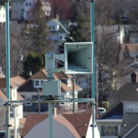
- Screenshot 2023-10-08 175803.png (1.65 MiB) Viewed 189505 times


This is definitely an electromechanical siren, confirmed from my recording. I will look for the surprise electronic siren later tonight.Eclipse DDS wrote: ↑Wed Sep 20, 2023 2:44 pmI would quickly like to bring to attention that there may be/have been a siren situated in Longtown, Carlisle. I have heard reports from some of my family members that they remember hearing one sounding when they were in the town, and from what I gather, this was relatively recently (within the last 30 years or so). I am not personally going to be devoting hours of time looking for this siren, but I wanted to bring it to attention for anyone who is more willing to find it.
Here is the town's location:
55.00995032642556, -2.966685277127862
https://www.google.com/maps/place/Longt ... ?entry=ttu
UPDATE:
Ok, so I did end up doing a little bit of searching. It turns out that MOD Longtown does have some emergency sirens, and there certainly are some siren-like shapes on-site. I will try and gather more information on the site's siren(s?). However, I do think that there may be some other warning sirens off-site, but I am unsure.
Helpful booklet mentioning the siren:
https://cumbria.gov.uk/elibrary/Content ... 581193.PDF
As of now, all I know is that there is at least 1 siren (referred to as the 'Site Emergency Siren' in the booklet) on-site, and that it is tested every Wednesday at 9:30 AM.
This might be something:
Screenshot 2023-09-20 175354.png
https://www.google.com/maps/place/54%C2 ... ?entry=ttu
Are you sure there's an Electronic siren? because all I hear is a GP6/GP10 wind up fast at the beginning and some sort of dual tone siren start up second.Eclipse DDS wrote: ↑Wed Nov 08, 2023 12:12 pmThis is definitely an electromechanical siren, confirmed from my recording. I will look for the surprise electronic siren later tonight.Eclipse DDS wrote: ↑Wed Sep 20, 2023 2:44 pmI would quickly like to bring to attention that there may be/have been a siren situated in Longtown, Carlisle. I have heard reports from some of my family members that they remember hearing one sounding when they were in the town, and from what I gather, this was relatively recently (within the last 30 years or so). I am not personally going to be devoting hours of time looking for this siren, but I wanted to bring it to attention for anyone who is more willing to find it.
Here is the town's location:
55.00995032642556, -2.966685277127862
https://www.google.com/maps/place/Longt ... ?entry=ttu
UPDATE:
Ok, so I did end up doing a little bit of searching. It turns out that MOD Longtown does have some emergency sirens, and there certainly are some siren-like shapes on-site. I will try and gather more information on the site's siren(s?). However, I do think that there may be some other warning sirens off-site, but I am unsure.
Helpful booklet mentioning the siren:
https://cumbria.gov.uk/elibrary/Content ... 581193.PDF
As of now, all I know is that there is at least 1 siren (referred to as the 'Site Emergency Siren' in the booklet) on-site, and that it is tested every Wednesday at 9:30 AM.
This might be something:
Screenshot 2023-09-20 175354.png
https://www.google.com/maps/place/54%C2 ... ?entry=ttu
https://youtu.be/YDOJ0t7OEyU
No, I’m not entirely sure, but I can only see one electromechanical siren-like shape on aerial view. The sound of the GP came from the forest area on the West of the site, and I cannot see any electromechanical sirens on aerial view so it may be in the forest somewhere. I mostly assumed electronic just because of the super-fast windup (and also I was pretty excited so I just said the first thought that popped into my head, heheh), but it probably was a Klaxon.BritishLSSystems wrote: ↑Wed Nov 08, 2023 11:00 pmAre you sure there's an Electronic siren? because all I hear is a GP6/GP10 wind up fast at the beginning and some sort of dual tone siren start up second.Eclipse DDS wrote: ↑Wed Nov 08, 2023 12:12 pmThis is definitely an electromechanical siren, confirmed from my recording. I will look for the surprise electronic siren later tonight.Eclipse DDS wrote: ↑Wed Sep 20, 2023 2:44 pmI would quickly like to bring to attention that there may be/have been a siren situated in Longtown, Carlisle. I have heard reports from some of my family members that they remember hearing one sounding when they were in the town, and from what I gather, this was relatively recently (within the last 30 years or so). I am not personally going to be devoting hours of time looking for this siren, but I wanted to bring it to attention for anyone who is more willing to find it.
Here is the town's location:
55.00995032642556, -2.966685277127862
https://www.google.com/maps/place/Longt ... ?entry=ttu
UPDATE:
Ok, so I did end up doing a little bit of searching. It turns out that MOD Longtown does have some emergency sirens, and there certainly are some siren-like shapes on-site. I will try and gather more information on the site's siren(s?). However, I do think that there may be some other warning sirens off-site, but I am unsure.
Helpful booklet mentioning the siren:
https://cumbria.gov.uk/elibrary/Content ... 581193.PDF
As of now, all I know is that there is at least 1 siren (referred to as the 'Site Emergency Siren' in the booklet) on-site, and that it is tested every Wednesday at 9:30 AM.
This might be something:
Screenshot 2023-09-20 175354.png
https://www.google.com/maps/place/54%C2 ... ?entry=ttu
https://youtu.be/YDOJ0t7OEyU
Users browsing this forum: No registered users and 7 guests